
Aim
White light interferometry allows the acquisition of height maps even of rough surfaces at the precision level of optical interferometry. We seek new methods of processing the raw data in order to produce height maps that are as close as possible to the real surface topography.
Methods
Scanning white light interferometers using CCD-cameras delivers a 3D data set consisting of time series-like sequences in every pixel of the imager. Due to the limited coherence length, interference can only be observed in a limited region of each sequence, the center of the oscillation being an estimate to the surface's height in that pixel. As the interference contrast can be poor on rough surfaces, the SNR varies from site to site, creating a challenge for signal detection.
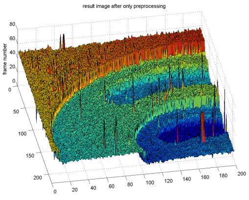
In a conventional approach, one tries to locate the center of interference for each sequence individually. This gives a primary height map which can be severely corrupted by outliers due to false detection. Filtering and smoothing operations can remove these outliers, but often reduce the lateral resolution and smooth over subtle features. This can hamper our understanding of surface functionality at a microscopic level.
To overcome these problems, we propose to make use of the complete 3D dataset in order to combine the detection and restauration process. This can be accomplished in a Bayesian framework.
The single-pixel data sequences are transformed to likelihood functions of data given height. Constraints on smoothness (in a neighborhood or even globally) are formulated as priors. Then the MPM (mean of posterior marginals) is used to estimate the height map. In this way, time and spatial constraints from the data are accounted for simultaneously.
The MPM procedure is complicated by the high dimensionality of the height configuration space. We propose two strategies to overcome this:
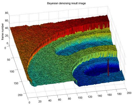
For selected local priors, the marginalization can be performed explicitly such that the global optimum is found with certainty. In spite of the prior's simplicity, the method outperforms the filtering schemes we compare to: the height error is well below of what can be achieved by conventional filtering or locally adaptive outlier detection schemes (Hampel detector).
For complex priors, we need to sample the a posteriori distribution using MCMC (Markov chain Monte Carlo) methods.
Examples / Preliminary results
A height map obtained using conventional, pixel-wise processing, showing artifacts:
Result after processing the raw data using a Bayesian surface estimator: