


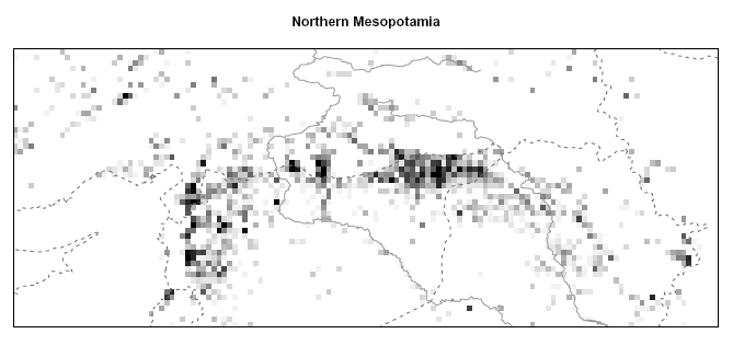
Figure: Spatial occurence of characteristic mounds in the SRTM elevation model. (Indicated are Euphrates and Tigris and the modern borders of Turkey, Syria, Iran and the Iraq. For details see publications below.)
Settlement Mounds
Tells are settlement-mounds which are found in the Near and Middle East, in an arc from the Balkans to north-west India, and represent prehistoric and early historic villages and towns. These were typically occupied for long periods of time, often several millennial, during which the mud-based building technique caused building-debris to accumulate, and build up into a substantial mound, giving advantages of visibility and protection. These prominent landmarks of early human activity began to appear when the spread of farming in the Neolithic period (8000-6000BC) gave rise to permanent villages, and such sites continued through to the Bronze Age (3000-1000 BC), when some grew to the size of major urban centers.
Although one or two are still inhabited, most of the mounds were abandoned two to three thousand years ago, and modern settlements exist on flat land nearby. These artificial mounds thus represent the remains of the earliest settlement systems, and a study of their spatial occurrence can reveal insights into the emergence, development and organization of the first complex human societies.
Satellite Survey
A machine based survey method has been developed for a fast, objective and systematic search of settlement mounds in North Mesopotamian landscapes. The objective of this purely digital survey is to obtain a highly accurate register of tell site locations, both to document minor sites and tells in remote regions for the first time, and to overcome the coarse positioning of well known major tells within existing listings.
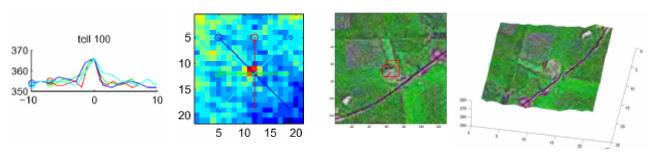
Figure: Principle of point detection: The characteristic height profile of a tell site generates a typical point like pattern in the DEM. Under the resolution of the SRTM DEM, their elevation is often of nearly conical shape (height profiles left, as indicated in the DEM image patch).
Search Algorithm
Central element of this project is the (semi-) automated search of characteristic tell patterns in SRTM digital elevation models. A nonlinear point detection algorithm has been trained on a data set of ground-thruthed tell sites. It is able to identify the characteristic point-like height profile of settlement-mounds in the elevation pattern of the natural land-surface with high sensitivity and specifity.
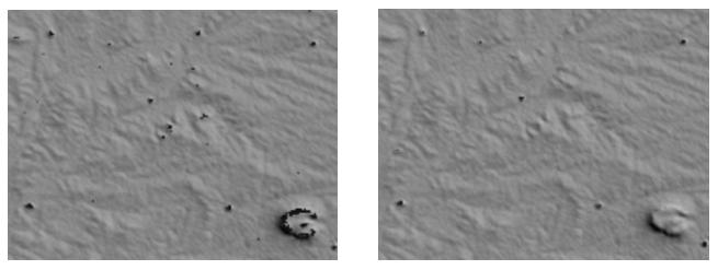
Figure: While a standard matched filter (left image) marks a considerable number of false positive hits (see black labeled pixels), preventing any computer-aided detection of settlement mounds, the designed classifier (right image) flags only a limited number of pixels with high specifity, allowing a time-efficient localization in high resolution LANDSAT images in a subsequent step. (The elevation in the right lower corner is of volcanic origin and has a diameter of approx. 2km.)
Publications
- Virtual survey on north Mesopotamian tell sites by means of satellite remote sensing
Menze, B.H.; Muehl, S. & Sherratt, A.G.
in: Ooghe, B. et al. (eds.), Broadening horizons. Multidisciplinary approaches to the study of past landscapes, Cambridge Scholars Press, to appear 2007
(preprint) - From eigenspots to fisherspots - latent spaces in the nonlinear detection of spot patterns in a highly variable background.
Menze, B.H.; Kelm, B.M. & Hamprecht, F.A.
in: Lenz, H.-J. & Decker, R. (eds.), Advances in Data Analysis. Studies in Classification, Data Analysis, and Knowledge Organization, Vol. 33, Springer, to appear 2007
(preprint) - Detection of ancient settlement mounds - Archaeological survey based on the SRTM terrain model
Menze, B.H.; Ur, J.A. & Sherratt, A.G.
Photogrammetric Engineering & Remote Sensing, 2006(3):321-27
(publisher)(preprint) - Tell spotting - Surveying Near Eastern settlement mounds from space
Menze, B.H.; Ur, J.A. & Sherratt, A.G.
in: Dequal, S. (ed.), Proceedings of the XXth CIPA International Symposium 2005, Torino/Italy, 2005, 217-223
(publisher) (preprint)
Links
 further information on ArchAtlas.org
funded by ![]()